
Woodborough’s Heritage
An ancient Sherwood Forest village, recorded in Domesday
FOX WOOD - A SURVEY OF VEGETATION
The survey was carried out by the members of the Lowdham WEA class of December 1985.
Tutor Mr M.L. Cooper B.Sc.,Cert.Ed.,M.I.Biol.
Members of the group included: Mr E. Stratton, Mrs I. Stratton, Mr J.E. Osborne, Miss M.J. Loakes, Mrs M.C. Hopkinson, Mrs M.A.L. Thornhill, Mr E.M. Brown, Mrs M. Cox, Mr D. Piggott, Mrs J. Nutting, Miss R. Osborne, Mr C. Pursglove, Mr H.J. Piggott.Historical research John Osborne.
AN INTRODUCTION TO THE FOX WOOD SURVEY
On the last Sunday in December 1985 the WEA class “Woods and Hedges” from Lowdham, met in Fox Wood near Calverton. The purpose of this meeting was to investigate the distribution of vegetation in the wood.
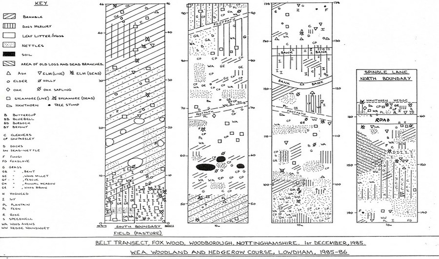
A line was strung through the centre of the wood and divided into ten metre sections. The class split up to plot a section at a time. Each species presented was recorded on a piece of paper if it occurred in an area five metres either side of the line. The positions and extent of the coverage were noted and subsequently transferred to a scale map. The results are interesting, although at first glance the wood appears to look much the same throughout.
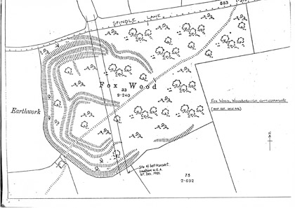
Fox Wood - An ancient woodland 1985 Vegetation Survey
Fox Wood o.s. Map showing the two parallel
lines as described in the text.
The map shows that in fact the vegetation follows a linear pattern, differing considerably on the north side. The species lists represent an ongoing investigation throughout the winter months. The class will be investigating the pattern of distribution at a later stage of the year.
HISTORICAL BACKGROUND OF FOX WOOD
An interesting feature of Fox Wood is the hill fort situated on the western side of the wood. Dating from at least the Roman occupation some 1900 years ago, the earthworks cover over half of the 9 acres of the wood, and are easily discernible on the western boundary. A large scale map of the site is probably needed to appreciate the extent and form of the earthworks as some parts are obscured by vegetation and other destroyed. The “Victorian History of Nottinghamshire” (1906) described the hill fort as follows: -
“The strongest position, approaching a square, as 3 sides of a vallum (rampart) and fosse (ditch); but one the eastern side they begin to curve outwards into another court, which possibly provided a well defended entrance into this innermost area. On the north is another court with the fosse remaining on the north (Spindle Lane side) and west side; at the north-east the defence changes into a vallum, which apparently, by the progress of the line, joined the northern entrenchments of the inner court; but the eastern side is lost. From the middle of the northern side a strong vallum, embracing all the inner works, passes around the western and southern sides, at the extremity of which it is destroyed; this entrenchment is probably older than the interior works. At the middle north point is an entrance, difficult of access, the agger (defensive earth bank) is here incurved, while another rampart, taking the same curve outwardly forms a sunken approach, which for 180 feet, even in its mutilated state, could be covered by crossfire from both sides.
On the western side the intervening ground between the inner fosse and out vallum widens into a broad platform. The position of this stronghold is the centre of many surrounding camps, and communication could easily be made with those at Lambley on the south; Lowdham and Thurgarton on the east; Epperstone and Oxton on the north; and the two in the parish of Arnold on the west”.
What must be remembered is that on top of the earth ramparts of the fort there would also have been a wooden palisade, which, together with the surrounding ditches, presented a formidable defence to any attacker. The fact that a fort was built where Fox Wood is now situated poses some interesting questions for the naturalist attempting a history of the site. It is assumed that for the fort to have been effective as defensive position then the site, initially, would have been devoid or have had little woodland in close proximity. On the other hand, woodland was essential for the provision of timber for the defences, fuel and housing.
Looking at the earthworks today, a good part appears to be relatively undamaged by agricultural practices such as ploughing, indicating the site in part at least, has developed naturally, but how long has the present woodland been there?
The search for information on the wood has necessitated visits to local libraries and the Nottingham Records Office [Nottinghamshire Archives] but, although a number of documentary sources have been examined, little mention of the wood has been found. Without written documentary evidence old maps of the county were consulted, and from these we have been able to date Fox Wood as being 175 to 190 years old.
The earliest map looked at was that by John Chapman in 1774, on which the Fox Wood site appears as a short eastward spur of Sherwood Forest. Between 1795 and 1798 the enclosure of Woodborough was completed and the enclosure map shows the Fox Wood site as belonging to the Rev’d. Philip Storey.*
*Note: We have subsequently encountered a work entitled “The History of Woodborough”, by the Rev’d. Walter Buckland as past vicar of Woodborough, which was published in 1897. From this we have learnt that the Rev’d. Philip Storey was of Lockington Hall, Leicestershire, and the cousin of Miss Elizabeth Bainbrigge of Woodborough Hall. When the Elizabeth Bainbrigge died in 1798, a spinster, the lands of Woodborough Hall Manor, which included the Fox Wood site, passed to Philip Storey. Elizabeth Bainbrigge was a descendent of George Lacock who bought Woodborough Hall from Strelley Bold during the middle part of the 17th century about the time of the Civil War. Bold was a descendent of the Woodborough branch of the Strelley family whose pedigree can be traced back to Ralph de Wodeburg, Lord of the Manor in the latter part of the 13th century.
Buckland conjectures that the manorial lands of Woodborough Hall are those attributed to Ulchel, an English thegn, in the Domesday Book, which records:- “M. In Udeburg (Woodborough) Ulchel had 3 bovates of land (assessed) to the geld. (There is) land for 2 ploughs. The same holds (it) of the King and has there 1 plough and 3 villeins and 1 border with 1½ ploughs and 1 mill (rendering) 20 shillings and 1 rod of meadow. Wood (land) for pannage 2 leagues in length and 5 furlongs in breadth. In King Edward’s time (it was worth) 20 (shillings); now (1986 it is worth) 30 shillings.”
It would be interesting, indeed, if the Fox Wood site was part of Ulchel’s woodland!
Since the death of Philip Storey the ownership of Woodborough Hall has changed on a number of occasions and the manor lands have been split and sold off at various times. Ownership of Fox Wood today therefore, is difficult to trace, but it is known that it is held by a Trust. As a result the future of the wood itself is, hopefully, secure.
The wood is not named but the western edge of the earthworks are clearly defined as part of a field boundary and, a short distance to the west, separated by an intervening field, is an area labelled “coppice allotment”, some 246 acres in extent. Fox Wood first appears as an entity on a County of Nottingham map of 1825, by T.J. Ellis, from survey work carried out in 1824 and 1825. But what is more informative is Saunders’ map of 1830 which shows the wood as “Foxwood Nursery”, indicating a young plantation. From our research then, we can say that Fox Wood came into existence sometime between 1798 and 1810. Which allows a margin for the trees to have developed sufficiently for them to be called a “wood” on the map of 1825.
What of the time before Fox Wood was planted? Even though our survey has been preliminary there is enough evidence to suggest that the site has, in the past, been old woodland. Chapman’s map of 1774 shows remnants of the old Sherwood Forest covering the area, but what is more important and reliable, is the evidence provided by the plants found in the wood today. These include wood sorrel, bluebells, yellow archangel, wood avens, wood millet, wood brome, dogs mercury, holly and field maple. Another indicator of old woodland is the number of species of fungi that can be found and, already, a fair number have been identified.
There is a large amount of investigative work to be done, both in the wood and the searching of old documents, before a detailed history of Fox Wood can be put together. However, if the work is as interesting as it has been in the first few months, then it will prove to be a fascinating project.
THE SURVEY OF FOX WOOD 1985
FUNGI
We were pleased to find a number of fungi in some of the sections that were surveyed. Most of these fungi, listed below, were found on dead or decaying trees in the wood where they are performing a process of recycling the nutrients available from the dead wood.
The following were identified:
- Stinkhorn
- Xylaria longpipes
- Gymnophilus junonius
- Sulphur tuft
- Pluteus salicinus
- Orange peel fungus
- Psathyrella candolleana
- Yellow cowpat
CONCLUSIONS FROM THE SURVEY OF FOX WOOD
Fox Wood is private property but, with access by bridleway and footpaths for the public. It has not been managed for many years. It is affected by the geology: clay; certain areas are often water-logged in wet seasons. The plants are typical of clay soil. Other factors which were thought to be playing a significant role in the distribution of wet vegetation in the area were: height above sea level; the weather; use by the public; and agricultural practices.
It is believed that the wood was clear felled during World War 2 which would explain why most of the trees are not more than 40 years old. The demise of elms within the wood has opened up the woodland floor to the light and therefore the young saplings of oak and ash should have a greater chance of survival. But bramble has invaded since the advent of Dutch elm disease which could have adverse effects on tree regeneration. The presence of ivy nettle and dock normally indicate disturbed ground.
From the belt transect it can be seen that there is a wide variety of plants living in the wood, and indeed continuing studies have extended the flora list considerably. Our preliminary findings point to the site being old woodland, but a document search has shown that the present woodland was planted about 1800.
NB. Since first writing this conclusion much research on the historical background of Fox Wood has been carried out by John Osborne and his findings are appended to the report.
Further research to the historical background to Fox Wood further research has borne out our theories on the site being one of old woodland. On another visit to the Nottingham Records Office [Nottingham Archives] a Sherwood Forest map of 1609 was seen and Fox Wood found to be marked. The surrounding fields were already enclosed, their outline is still distinguishable on today’s maps, but more interestingly, Fox Wood extended further to the south-east. On the enclosure map of Woodborough of 1798, the outline of the wood is discernible from the shape of the fields, but not named. As the wood had assumed the shape it is now by 1825 (Ellis map), it seems that the remainder had been cleared soon after the Enclosure Award. More information has come from “The Place Names of Nottinghamshire”, in which Fox Wood is traced back to the thirteenth century.
The wood is identified with the “Bosc. De Wodeburg vocat. Foxthweyt” in the Forest Proceedings of 1287; “Foxtheyt” in the 1335 Forest Proceedings and Foxwayte” in the Proceedings of the time of Henry VIII.
Foxthweyt is a hybrid compound of ‘fox’ and an old Scandinavian word ‘thwait’, meaning clearing or small enclosure, hence ‘Fox-clearing’, which later became corrupted to Fox Wood. This being the name recorded in the Land Revenue Miscellaneous Book, 1609, and on the Sherwood Forest map mentioned above.
Acknowledgement:
- Lowdham WEA 1985.
__________________________________________________________________________________________
- Toadstool
- Lycoperdon pyriforme
- Jews ear
- Coral spot fungus
- Tripe fungus
- Dryads saddle
- Slipper fungus
- Velvet shank
- Oyster mushroom
GROUND LAYER PLANTS
- Hedge woundwort
- Wood avens
- Greater plantain
- Stinging nettle
- Broad leaf dock
- Hogweed
- St John’s wort perforate
- Cleavers
- Wood sorrel
- Bluebell
- Clustered dock
- Blackberry
- Oxford ragwort
- Dogs mercury
- Ivy
- Rosebay willow herb
- Creeping buttercup
- Lesser burdock
- Broad leaf willow herb
- Lords and Ladies
- Gooseberry
- Hawkweed sp.
- Yellow archangel
- Foxglove
- Cow parsley
- Wood Brome
- Cocksfoot
- Wood millet
- Annual meadow grass
- False oat grass
- Lepidoptera
- Large white
- Comma
- Mollusca
- Limax temellus
- Oxychilus alliarius
- Crustacean
- Trichoniscus pusillus
- Philoscia muscorum
- Myriapods
- Polydesmus complanatus
- Cylindroiulus Sylvarum
- Coleuptera
- Stenus clavicornis
- Notiophilus palustris
- Tochyporus hypnorum
- Trechus quadristriatus
- Coccinella 7-punctate
- Propylea 14-punctata
- Diplura
- Two-pronged bristle tail
- Arachnida
- Zygiella atarica
- Erigone atra
INSECTS/ARACHNIDA
BIRDS, MAMMALS & AMPHIBIANS
- Wren
- Jay
- Robin
- Chaffinch
- Wood pigeon
- Blue tit
- Bullfinch
- Great tit
- Coal tit
- Long-tailed tit
- Brambling
- Great spotted woodpecker
- Tawny owl
- Dunnock
- Blackbird
- Tree creeper
- Gold crest
- Magpie
- Jackdaw
- Mole
- Field vole
- Bank vole
- Wood mouse
- Frog
| Navigate this site |
| 001 Timeline |
| 100 - 114 St Swithuns Church - Index |
| 115 - 121 Churchyard & Cemetery - Index |
| 122 - 128 Methodist Church - Index |
| 129 - 131 Baptist Chapel - Index |
| 132 - 132.4 Institute - Index |
| 129 - A History of the Chapel |
| 130 - Baptist Chapel School (Lilly's School) |
| 131 - Baptist Chapel internment |
| 132 - The Institute from 1826 |
| 132.1 Institute Minutes |
| 132.2 Iinstitute Deeds 1895 |
| 132.3 Institute Deeds 1950 |
| 132.4 Institute letters and bills |
| 134 - 138 Woodborough Hall - Index |
| 139 - 142 The Manor House Index |
| 143 - Nether Hall |
| 139 - Middle Manor from 1066 |
| 140 - The Wood Family |
| 141 - Manor Farm & Stables |
| 142 - Robert Howett & Mundens Hall |
| 200 - Buckland by Peter Saunders |
| 201 - Buckland - Introduction & Obituary |
| 202 - Buckland Title & Preface |
| 203 - Buckland Chapter List & Summaries of Content |
| 224 - 19th Century Woodborough |
| 225 - Community Study 1967 |
| 226 - Community Study 1974 |
| 227 - Community Study 1990 |
| 400 - 402 Drains & Dykes - Index |
| 403 - 412 Flooding - Index |
| 413 - 420 Woodlands - Index |
| 421 - 437 Enclosure 1795 - Index |
| 440 - 451 Land Misc - Index |
| 400 - Introduction |
| 401 - Woodborough Dykes at Enclosure 1795 |
| 402 - A Study of Land Drainage & Farming Practices |
| People A to H 600+ |
| People L to W 629 |
| 640 - Sundry deaths |
| 650 - Bish Family |
| 651 - Ward Family |
| 652 - Alveys of Woodborough |
| 653 - Alvey marriages |
| 654 - Alvey Burials |
| 800 - Footpaths Introduction |
| 801 - Lapwing Trail |
| 802 - WI Trail |